

Description
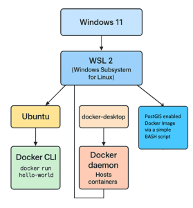
This course focuses on training GIS students to integrate these two powerful tools—PostGIS and Docker—to streamline GIS workflows and facilitate reproducibility in geospatial projects. By building a PostGIS-enabled Docker image, users can create isolated environments that simplify database management, eliminate compatibility issues, and optimize deployment processes. For personal computers or notebooks, this approach offers a significant advantage: the database can be backed up to an
external device, either at regular intervals or at critical moments, and restored to the user’s computer or another device as needed. This ensures both data security and ease of transfer across systems.
The aim is to empower GIS students to harness the flexibility of Docker and the advanced functionalities of PostGIS, paving the way for more efficient data handling and deployment in GIS applications. Whether you’re a seasoned GIS developer or exploring new ways to enhance your workflows, this integration offers a scalable and adaptable solution for modern geospatial challenges.
Reviews
There are no reviews yet.